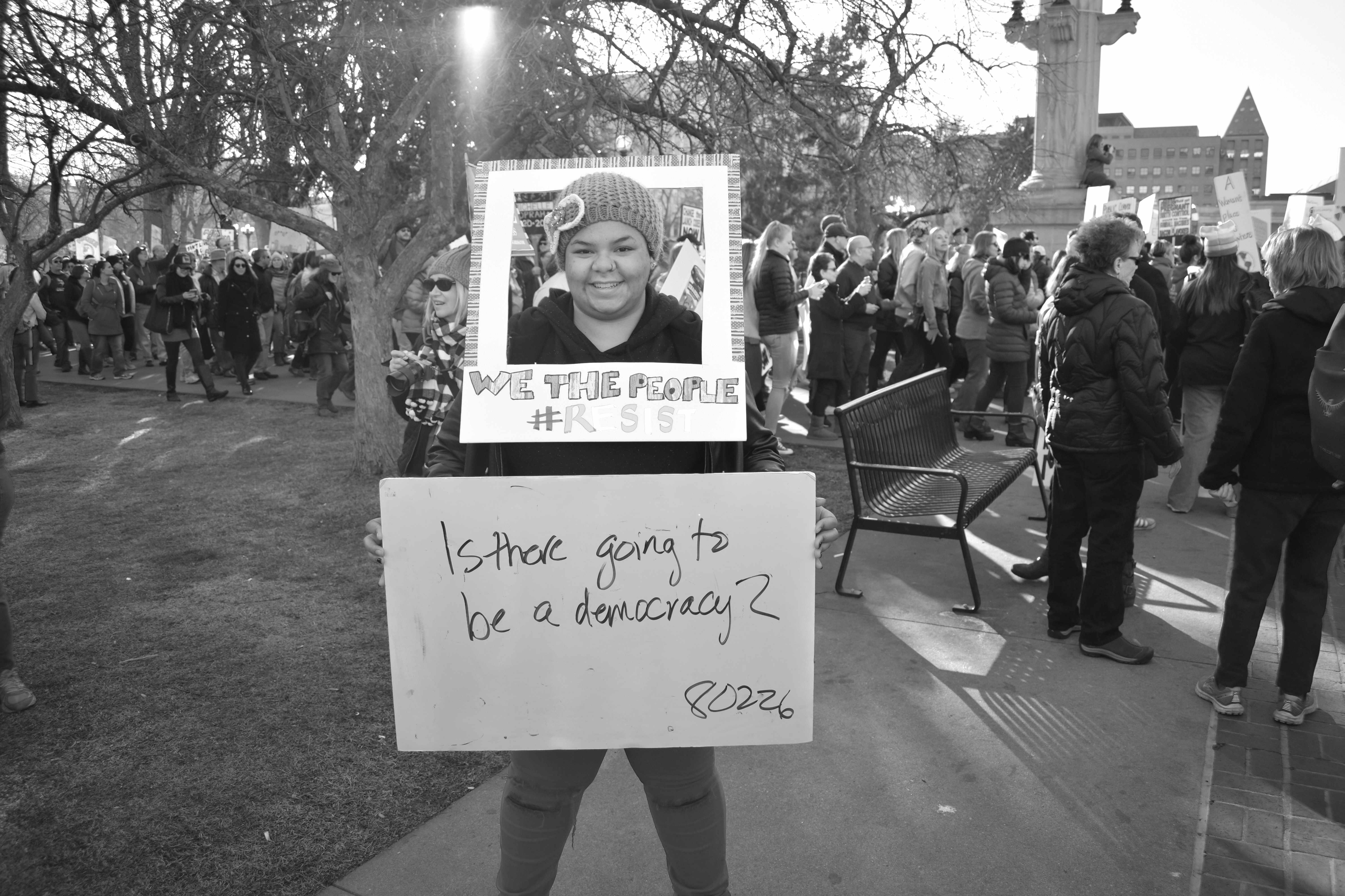
Is there going to be a democracy?
Are brands more powerful than governments?
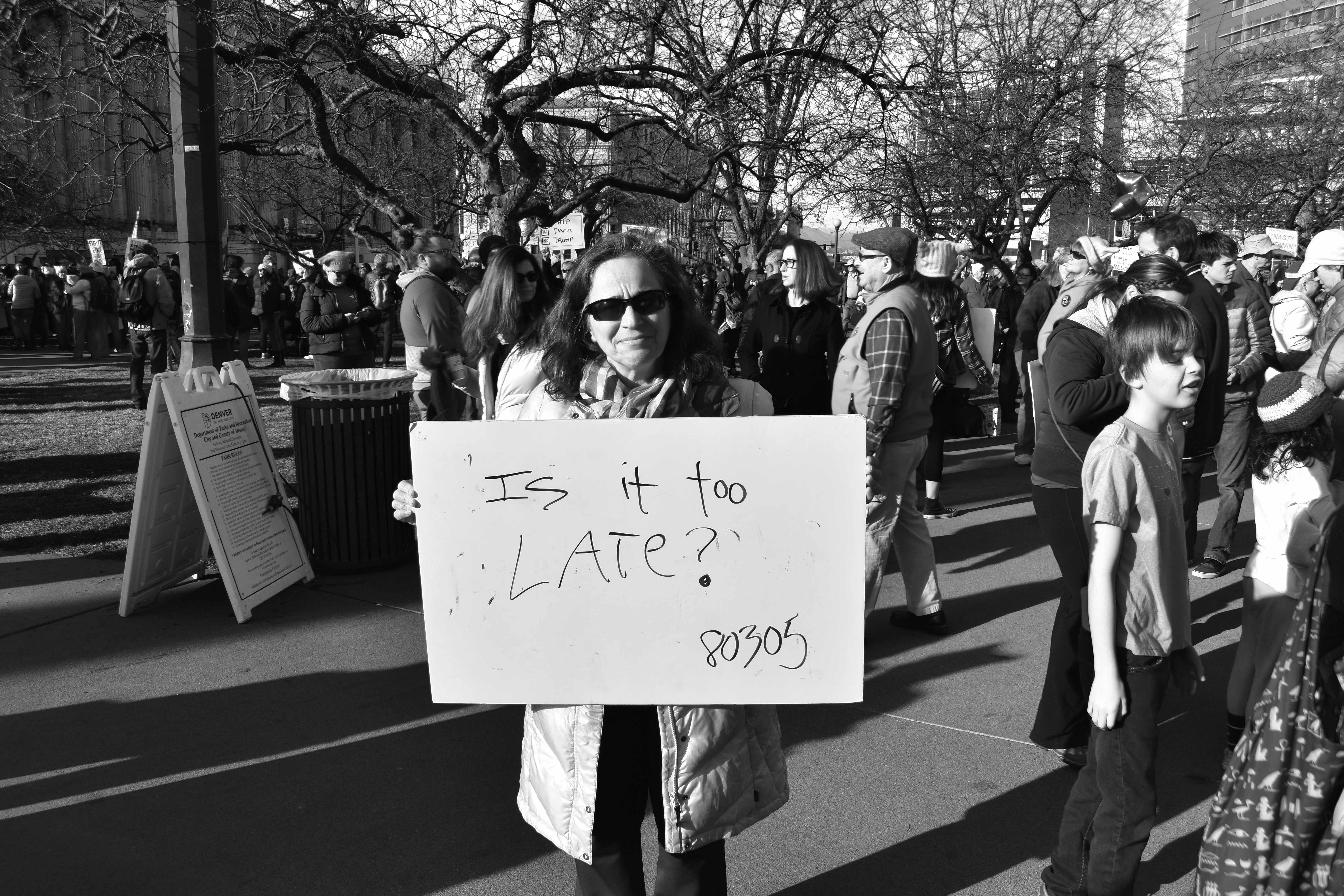
What does democracy feel like? Is it too late?
Not a map of land. A map of us — how we think, what we carry, and where our civic imagination can take us next. Built by communities. Rooted in a tradition of people who have always had to draw their own maps to survive.
What question do you carry for the future of America?
Our Voices Unbound is a bold, creative, community-driven initiative to map the civic moment we're living through. Not with polls. Not with punditry. With the actual voices of people across the country — surfaced, connected, and made visible in ways that help us see ourselves and each other more clearly.
We're asking one question: "What question do you carry for the future of America?" And we're meeting people everywhere — through community gatherings, creative media, social platforms, and face-to-face conversation. Using technology to hold and honor what people share — including immersive experiences that bring our questions to life. Always together. Always where people are at in this moment.
Each response becomes a coordinate on a new kind of map. Together they form a living picture of where we are nationally — and a terrain for charting where we go next. This is world-building. New storytelling. Seeing ourselves into the future together.
Community gatherings designed for honest, facilitated civic dialogue
Creative media & social platforms meeting people in their feeds, inboxes, and lives
Documentary technology giving communities ownership of their own stories and data
AI-assisted sensemaking that surfaces patterns and wisdom — not opinions or noise
Immersive experiences that use technology to bring our civic questions to life
When the official maps erase you, you draw your own. Indigenous communities mapping ancestral lands the state refuses to recognize. Marginalized neighborhoods documenting what was there before the highway came through. Activists exposing the invisible architecture of power. From Indonesia to the American South to Berlin, this impulse is universal: when the world won't see you, you make yourself visible.
Long before the term "counter-mapping" existed, Indigenous peoples across the globe were creating their own spatial knowledge — mapping ancestral territories, seasonal cycles, and spiritual geographies that colonial cartography deliberately erased. In the 1990s, forest communities in Kalimantan, Indonesia created maps to contest government claims on their land. Zapatista communities in Chiapas drew territorial maps emphasizing relational understandings of space. The impulse is ancient and global: communities mapping their own reality against the maps of those who would erase them.
 Interstate Highway plan, 1970. Highway construction displaced thousands of families and communities. Wikimedia Commons / Public Domain
In the United States, the NAACP mapped the location and frequency of lynchings — not as geography, but as evidence. Their 1919 publication Thirty Years of Lynching in the United States used hand-drawn maps whose shading darkened with each additional murder. As the Library of Congress observed, these maps showed more than any narrative possibly could.
The Student Nonviolent Coordinating Committee mapped networks of power — which officials, corporations, banks, and law enforcement sustained racial discrimination. Their research department created "power-maps" showing the economic and political connections between institutions invested in sustaining white supremacy. Not location maps. Maps of how oppression worked.
112 thinkers from around the world gathered at a single round table in Berlin to answer 100 questions about the state of humanity. A landmark experiment in collective sensemaking — making visible the patterns in how people from vastly different contexts think about the same urgent questions. The direct DNA of Our Voices Unbound.
Artist Tonika Lewis Johnson paired addresses on racially divided sides of the same Chicago street, photographing "map twins" to expose how segregation remade an entire city. The Folded Map Project became a mirror — and a meeting point.
Across the globe, communities are using restorative mapping to bring visibility to experiences that were marginalized or forgotten. In the U.S., researchers Inwood and Alderman are recovering the hidden history of Black mapmaking. In Colombia, social cartography is challenging extractive representations of indigenous territories. Digital tools are making it possible for communities everywhere to restore a sense of place through collective memory.
And now this. Not mapping land or infrastructure or even power networks — but mapping civic consciousness itself. How communities are thinking, feeling, imagining, and carrying questions for the future. A new cartography for a new moment — charting territory that doesn't exist on any map yet. The territory of who we can become together.
"Resistant cartographies stretch what constitutes a map, the political work performed by maps, and the practices, spaces, and political-affective dimensions of mapping."Inwood & Alderman, adapted from The Living Black Atlas
Every map needs instruments. The CKT is ours — an AI-assisted sensemaking engine that helps surface what's already living inside community voices. Not opinions. Not sentiment scores. Patterns of meaning — how people orient toward the past, the present, and the future. Whether they speak from individual experience or collective identity. What emotions carry their words.
The CKT doesn't tell us what to think. It helps us see the civic terrain more clearly — so communities can decide for themselves where to go next.
Civic imagination isn't abstract. It's the practice of communities looking at where they are, honestly, and then asking: what else is possible? The futures are already living inside people's voices. Futures that polls can't see. Futures that algorithms suppress. Futures that belong to the people who carry them.
ourvoicesunbound.org